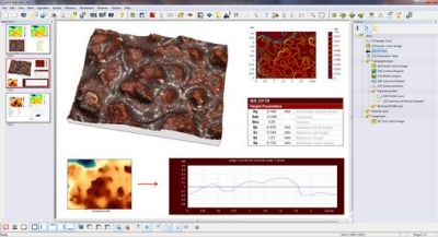
February 1, 2011 — Leica Microsystems and Digital Surf announced an agreement whereby Leica Map surface imaging and metrology software, based on Digital Surf’s Mountains Technology, will be used with the Leica Application Suite (LAS) for Leica industrial microscopes. The Leica Map software is used to visualize and quantify features of measured surfaces, characterize surface texture and geometry, and generate visual surface metrology reports with full traceability. It is available on three levels with optional modules for advanced applications.
 Entry-level Leica Map Start software is used in conjunction with LAS Montage. LAS Montage acquires a series of image planes at known spacing covering the in-focus region of a specimen with a Leica microscope. From this stack a depth map and an extended focus image are derived and analyzed by Leica Map. In Leica Map Start, surface topography can be viewed at any zoom level and any angle in real time. Color and intensity image overlays facilitate the location of surface features, including defects. Distances, angles, and step heights can be measured. Height and functional parameters are calculated in accordance with the latest ISO 25178 standard on areal surface texture. Optional modules can extend the capability to surface texture and contour analysis.
Leica Map DCM 3D software is dedicated to the Leica dual core 3D microscope Leica DCM 3D, which combines confocal and interferometry technology for non-invasive, high speed, and high-resolution assessment of micro and nano structures. In addition to the standard features of Leica Map Start, Leica Map DCM 3D includes advanced ISO 16610 filtering techniques for separating surface roughness and waviness, basic functional analysis (bearing ratio, depth distribution, etc.), and the ability to extract sub-surfaces (for example from mechanical and electronic components and MEMS) and analyze them independently.
Leica Map Premium is a top of the line universal solution that is compatible with single-point tactile and optical profilometers and scanning probe microscopes, as well as with optical microscopes.
"Leica Map software is based on the latest generation of Mountains Technology, which was released in the second half of 2010," stated François Blateyron, COO of Digital Surf. "It incorporates an enhanced desktop publishing environment, to speed up complex calculations and the processing of large measurement data sets."
Leica Microsystems provides microscopes and scientific instruments. Leica Microsystems is organized in four divisions: the Life Science Division, Industry Division, Biosystems Division and Medical Division.
Digital Surf provides imaging and analysis software for surface metrology instruments including confocal microscopes, optical interferometric microscopes, scanning probe microscopes and 2D/3D profilometers.
Follow Small Times on Twitter.com by clicking www.twitter.com/smalltimes. Or join our Facebook group


can you tell me what routhness parameters the software uses in order to calculate the surface of nano stractures?